Home / Neighborhoods / Broad Beach
Broad Beach Homes for Sale in Malibu
The oceanfront row running west from Trancas Creek to Lechuza Point, on one road with two ends.
Home / Neighborhoods / Broad Beach
The oceanfront row running west from Trancas Creek to Lechuza Point, on one road with two ends.
About the Neighborhood
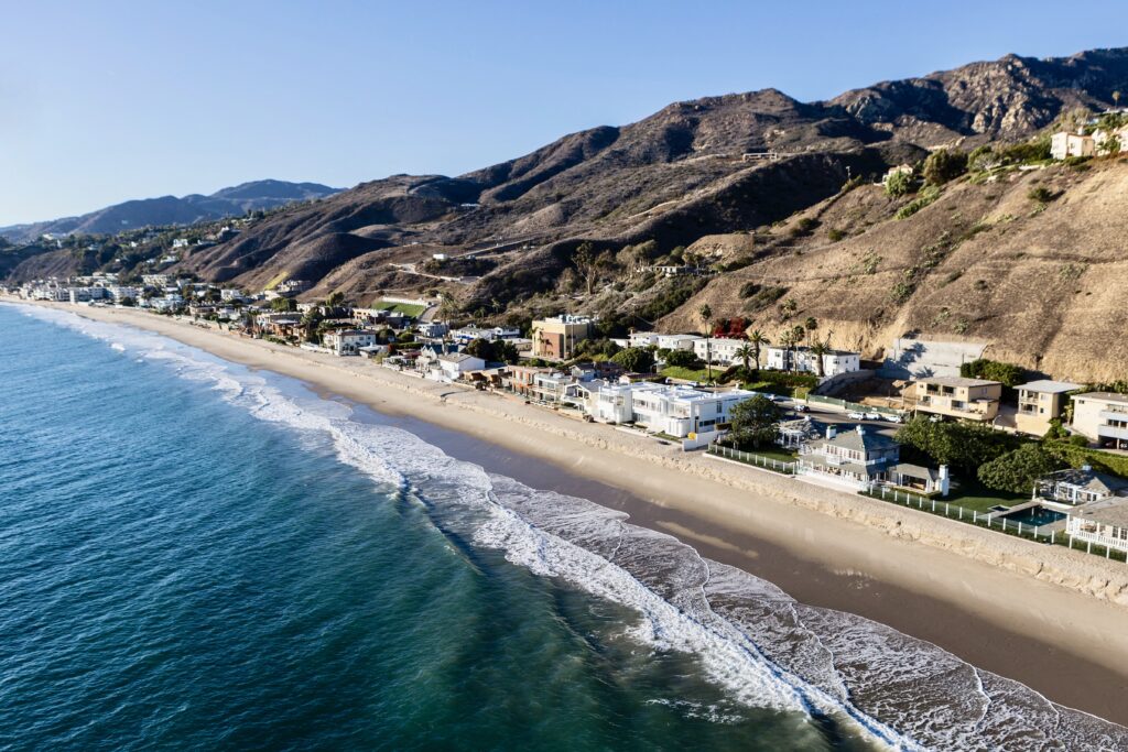
Broad Beach is the oceanfront strip that runs west from Trancas Creek to Lechuza Point on Malibu's western shore, addressed almost entirely along Broad Beach Road, a loop that leaves Pacific Coast Highway at each end. The City of Malibu's own project filings describe roughly a mile and a half of shoreline fronting approximately eighty homes, which makes this one of the longest continuous private beachfront rows in the city. Zuma and Trancas beaches lie to the east, the Malibu West and Trancas neighborhoods sit inland, and Point Dume's headland closes the horizon down-coast. Anyone shopping Broad Beach Malibu real estate is looking at a single road, two ends, and a shoreline that has been measurably changing for fifty years.
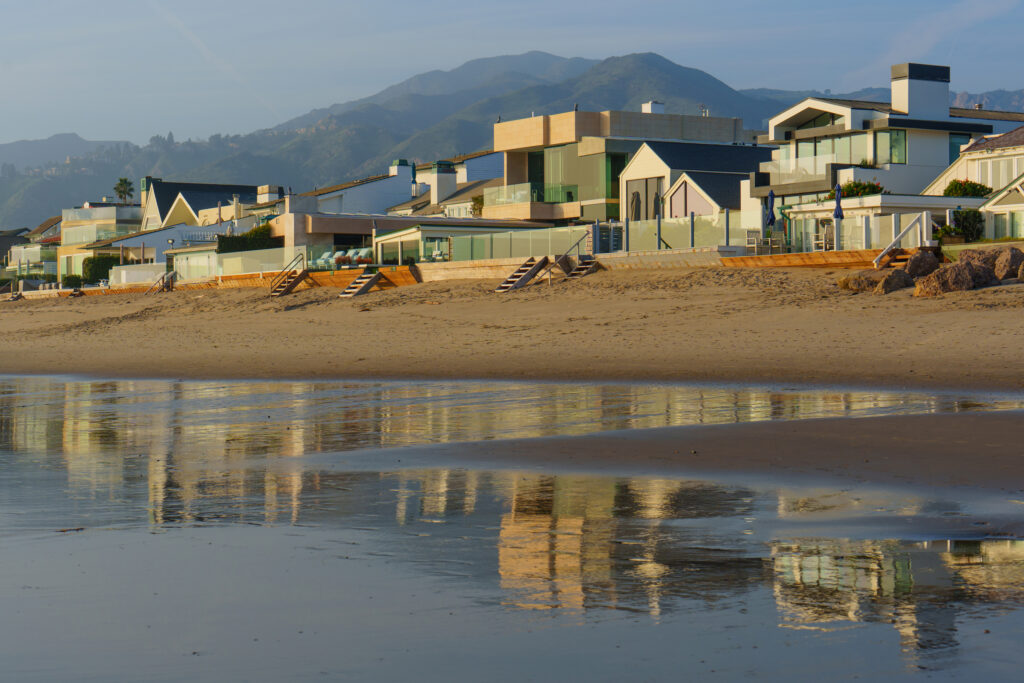
The house stock reads as a fifty-year accumulation rather than a tract. Postwar beach houses remodeled several times over stand beside full contemporary rebuilds on the same narrow oceanfront parcels, most of them deeper than they are wide and pinched between the road and the tideline. Foundations are the tell here: caissons, grade beams, timber bulkheads and, since 2010, rock. Across the road, landward lots rise toward Trancas and Malibu West with ocean views but no sand, and they trade on entirely different fundamentals. Documented recent work includes Michael Maltzan Architecture's Broad Beach Residence, completed in 2020, whose protective berm, lifted volumes and salt-tolerant finishes fairly summarize what building on this beach now demands.
The sand story is the neighborhood's defining fact. Scholarship published in the Pacific Historical Review traces the mean high tide line moving landward at roughly two feet a year from about 1974, with something on the order of 600,000 cubic yards of sand lost between 1974 and 2000 and about sixty-five feet of beach gone by the turn of the century. Reduced sediment delivery, coastal armoring and shifting storm cycles are the causes usually cited. After the punishing winter of 2009 to 2010, owners placed an emergency rock revetment along the frontage between roughly 30760 and 31346 Broad Beach Road, described in city filings as about 77,000 tons of stone built between February and April 2010.
The permanent fix has never arrived. The Broad Beach Geologic Hazard Abatement District, approved by the City of Malibu on September 12, 2011, was formed to fund and build a sand-restoration project: an initial nourishment, a restored dune, periodic renourishment, and retention and eventual burial of the revetment. The district reports a consolidated coastal development permit from the California Coastal Commission in October 2015 and State Lands Commission approval in August 2016. Implementation then stalled. Courts found the assessment structure unconstitutional beginning in 2019, an appellate decision followed in 2022, and a November 2025 ruling in a collection dispute with a neighboring club again put the district's ability to levy in question. As of August 2026, no sand has been placed.
Two questions follow every buyer here. The first is access. This is a public-private beach, the boundary is the mean high tide line, and something under half the parcels historically carried recorded dry-sand easements of widely varying depth, with vertical accessways near Sea Level Drive and Bunnie Lane and further easements identified in the Coastal Commission's Malibu access guide. The second is diligence. Ask for the revetment's condition and permit history, the parcel's exact easement language, the septic system's capacity and permit status, the coastal permit file behind every past addition, and a current wave run-up analysis. Winter, when high surf meets king tides, is the honest season to walk a frontage you are serious about.
Life Here
A mile and a half of continuous shoreline with no piers, no restaurants and no road noise carrying down to the water, bounded by Trancas Creek at one end and Lechuza Point at the other.
The 2010 emergency revetment runs along much of the frontage. It is the reason many houses are still standing and the reason the restoration project exists; on this road, geology is a household topic.
Markets, coffee and everyday errands sit minutes east at the Trancas centers, with Zuma and Westward beyond, so the road itself stays entirely residential.
History
Western Malibu came late to subdivision, and that is the root of Broad Beach's character. The whole coast here sat inside Rancho Topanga Malibu Sequit, the roughly 13,300-acre grant Frederick and May Rindge acquired in 1892, and May Rindge spent decades resisting a public road across it. She lost that fight when the state opened the Roosevelt Highway, today's Pacific Coast Highway, in 1929. Only after the ranch broke up did beach parcels this far west come to market in any quantity, and building along the strand accumulated house by house through the postwar decades rather than arriving as a planned tract, which is why no two frontages on the road are quite alike.
The erosion record begins in the 1970s and reads like a slow emergency. By the early 2000s a beach that had been genuinely broad was, in one scientist's phrase quoted in the Pacific Historical Review, closer to an invisible beach at high tide. In June 2005 homeowners bulldozed a sand berm without permits, an episode that hardened public suspicion of the row. The winter of 2009 to 2010 forced the issue, and an emergency rock revetment went in under city and Coastal Commission emergency authorization, roughly 4,100 feet of stone along the frontage. Retaining it long term became the central bargaining chip in everything that followed.
Access has been the second running thread. Only two vertical accessways served the stretch by the early 2000s, both established in the 1940s before the Coastal Commission existed, and roughly half the parcels carried public easements of confusingly varying depth. Misleading signage and private security became well documented, including a 2003 incident in which a former Coastal Commission chair was confronted while sitting on publicly accessible sand. Jenny Price's Los Angeles Urban Rangers and the 2013 Our Malibu Beaches app were direct responses. When the Commission conditioned the restoration project on lateral access over the revetment, it was writing that history into the permit.
Architecture
Geometry dictates almost everything. Oceanfront lots here are narrow and deep, wedged between the road and the tideline, so houses arrange themselves as a sequence rather than a composition: motor court and entry on the street side, service and bedrooms in the middle, and the full width of the parcel given over to living space and glass facing the water. Roof decks and second-floor terraces do the work that a garden would do elsewhere. Landward parcels across the road invert the logic entirely, sitting higher with longer views over the rooftops and none of the exposure, which is why they read as a separate market rather than a cheaper version of the same one.
What is underneath matters more than what shows. Beachfront construction here rests on caissons and grade beams, often behind timber bulkheads, and since 2010 behind rock as well. Malibu's code applies stringline setbacks on beachfront lots in places, tying how far seaward a new dwelling or deck may extend to the alignment of the closest upcoast and downcoast structures, and coastal hazard analysis, wave run-up modelling and finished-floor elevation drive the rest of the envelope. Confirm what applies to a specific parcel before assuming anything. Materials follow the same discipline: salt-tolerant metals, board-formed and cast concrete, and finishes chosen for corrosion resistance rather than fashion.
The result is a stylistic range held together by structural necessity. Original postwar beach houses survive in remodeled form, many enlarged repeatedly under successive coastal permits, and they sit beside contemporary rebuilds designed by named practices. Michael Maltzan Architecture's Broad Beach Residence, completed in 2020, uses lifted volumes, an erosion berm and degradation-resistant surfaces as explicit answers to the site; Kovac Design Studio's Broad Beach project works in cast concrete and bronzed metal with a curved roofline and column-free operable glass toward the water. Both illustrate the current standard, which is that on this beach the architecture and the coastal engineering are the same conversation.
Understanding the Market
Pricing on this road sorts by a short list of variables, and view is not the first of them. Frontage width, the depth of dry sand in front of the house, whether the parcel sits behind revetment, and the recorded public easement across it do more to set value than square footage. The Trancas end trades on convenience and slightly more sheltered water; the Lechuza and Victoria Point end trades on seclusion and the rocky drama of the point. Landward lots across the road form a distinct and considerably deeper tier. Buyers comparing Malibu beachfront homes for sale should price these attributes separately rather than as one number.
The unresolved sand project sits over everything as a diligence item rather than a deal-breaker. Sophisticated buyers treat it the way they treat a pending assessment or an open permit: something to be quantified in writing during escrow, with the revetment's condition, the septic system, the coastal permit history and the insurance quote handled in the same pass. Escrows here commonly run longer than elsewhere in Los Angeles to accommodate that work, and experienced local agents regard that as normal rather than as a warning sign. Sellers who assemble the file in advance consistently transact more cleanly than those who do not.
Documented trades give a sense of scale without substituting for current analysis. The Real Deal reported a Broad Beach home selling for $19.65 million in 2022 and subsequently offered for lease, and in July 2026 reported 30810 Broad Beach Road entering contract at an asking price of $21.5 million, noting the same property had last sold in 2002 for $4.9 million. Read those as widely reported data points about a thin, idiosyncratic market rather than as comparables. On a road of roughly eighty houses, a handful of trades in a year is a normal volume, and one unusual sale can distort an average badly.
Micro Neighborhoods
The ocean side of Broad Beach Road is the market most buyers mean when they say Broad Beach: narrow, deep parcels sitting directly on the sand, roughly eighty of them by the city's count, running the full distance from Trancas Creek to Lechuza Point. Houses here range from heavily remodeled postwar originals to recent architect-led rebuilds, and nearly all sit on engineered foundations with bulkheads or revetment below. This is where the sand-loss story, the recorded public easements and the GHAD assessment questions all land, so it is also where diligence takes the longest and matters the most.
Across the road, parcels rise toward Trancas and Malibu West with ocean outlook over the beachfront rooftops and none of the shoreline exposure. Lots tend to be wider and more conventionally usable, gardens are possible, and the coastal engineering questions that dominate the sand side largely fall away. What buyers give up is the beach itself, which they reach on foot by way of the public accessways rather than through their own gate. For many households the trade reads well, and the tier prices at a meaningful discount to the frontage a hundred feet south.
The eastern end of the road, near Trancas Creek, is the most connected part of the stretch. Public vertical accessways sit near Sea Level Drive and Bunnie Lane, so this is where beachgoers arrive and where the dry-sand easement pattern is most visible on the ground. Markets, coffee and everyday errands are minutes away at the Trancas centers, and Zuma is just beyond. Buyers who want the beach without a fifteen-minute drive for a carton of milk gravitate here, accepting more foot traffic in summer as the price of that convenience.
The western end runs out toward Lechuza Point, where the sand narrows and gives way to rock and tidepool. Parcels here feel more remote, the surf reads rougher, and the sense of being at the edge of the developed coast is strongest. This is also where some of the sharpest disputes over the restoration project and its access conditions have played out, since one holdout owner's refusal to grant lateral access was reported as fatal to the permit as approved. Buyers drawn to this end are usually buying quiet and horizon rather than convenience.
The headland southeast of Broad Beach anchors the western Malibu view and offers the obvious alternative for buyers weighing sand against land. Point Dume's mesa streets carry larger, flatter lots, ranch houses from the 1950s and 1960s alongside contemporary rebuilds, equestrian zoning in places, and private bluff-stair beach access in the gated pockets. Shoppers comparing gated communities in Malibu and beachfront rows often tour both in a single day. The choice usually comes down to whether the ocean should be underfoot or a hundred feet below, and how much coastal engineering a household wants to own.
View Point Dume, Down-CoastEducation
All four public campuses currently belong to Santa Monica-Malibu Unified; separation agreements for an independent Malibu district were approved in December 2025 with state-level steps and a separation window reported for 2027 to 2029. Assignment always follows the individual parcel, so confirm any specific address with the district before relying on it.
Common Questions
Work With Ben
Tell me which end of the road you want and what you will accept on sand width, and I will track Broad Beach listings for you, including houses that trade off market. The diligence on this stretch is specific, and it is worth doing before you write an offer rather than after.
Start the ConversationBen will reach out shortly to set up your tour.